|
|
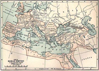
The Roman Empire at its Greatest Extent about 117AD,
Matthew-Northrup Co |

|
This
map, which is commonly used in many schoolbooks, aims to show the
influence of the Roman Empire. There are, however, several errors:
A) The conquest of Mesopotamia lasted only about 3 years. Therefore,
the present map doesn't make any more sense than a map showing, for
instance, the Third Reich at its peak.
B) North of the Danube, Rome occupied only present-day Transylvania.
Thus, the extent of Roman Dacia including Wallachia, i.e Southern
Romania, is wrong.
C) Scotland North to Hadrian's Wall was occupied only prior to 110 AD
and after 142 AD. The Empire never reached simultaneously the maximal
extent shown here.
D) The Southern frontier into the desert is somewhat exaggerated. In fact, Rome effectively controlled only the coastal areas.
C) Armenia and the Caucasian countries (Colchis, Iberia, Albania) were
vassal states. The real Roman authority on them is unclear.
By various means, this well-known map gives the impression that the Empire was bigger than it was in reality.
|
|
|
|