|
|
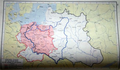
| Territorial changes of the Polish state in the course of its history, The Historical Atlas of Poland, Wroclaw 1981, p.54 |

|
The
clear aim of this map is to show the territorial changes and spatial
displacements of Poland during the last millenium. There are, however,
two problems:
A) Throughout the past centuries, the feeling of a common Polish
identity was not as palpable as it is today. For instance, it's
doubtful that Pomerania and Mazovia, which seem to be at least partly
included in the core area, were among the "founders" of the Polish
state.
B) A romantic or superficial reader could consider that the large areas
in white on the map of "Historic Poland" have been "stolen" from
21st century Poland by malicious neighbours: Russia, Belarus, Ukraine,
Lithuania, Czech Republic, Slovakia, Germany etc.
It may be noted that superimposing this map with the previous one of Belarus, could be contradictory.
|
|
|
|