|
|
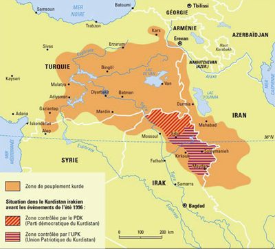
The Kurds, a people divided, from Le Monde Diplomatique,
map presented in the magazine's website: http://mondediplo.com
|

|
It
is difficult to understand the aim of this 20th century Middle -East
map on which a superimposed orange area shows the lands with Kurdish
populations.
Reasonably, one could consider that:
A) The orange area should become a Kurdish state?
B) Some Kurds, whether in the majority or minority, are living in the orange zones?
C) Turkey, Armenia, Syria, Iraq, and Iran shared Kurdistan like Russia, Austria and Prussia shared Poland in the 18th century?
D) The orange area represents an antique Kurdish state? This is erroneous.
In any case, such a map is less useful than, for instance, a map of the
Middle East indicating social statistics (i.e. the degree of
health insurance coverage within the various countries).Moreover,
contradictions could be visible if this map is superimposed onto the
previous map of Greater Armenia.
|
|
|
|