|
|
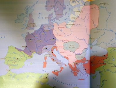
Europe and Mediterranean c. 750,
Maldaque et al. nouvel Atlas d'Histoire. Bruxelles 2003, p. 55
|

|
On
this map, only two real states appear: the Frankish Kingdom, in dark
purple, and the Roman Empire, commonly called "Eastern" or "Byzantine",
in dark orange. All other shown entities were not states.
The lands inhabited or mastered by people called Arabs, in fact by
Muslims, are green. Lands settled or dominated by people speaking a
Slavic language are pink and light purple denotes the presence of
Germans, i.e. persons allegedly related to the inhabitants of the
Frankish Kingdom. Some other groups are shown in light blue, grey, and
light yellow.
In short, the map above is mixing political entities with supposed DNA
groups, faiths, theoretical languages, and dominant groups in such a
manner that if it were a physical map some of the distances would be in
miles, some others in yards, and the remaining in walking days, if not
in wavelengths.
|
|
|
|